No country can have a first-rate economy without a first-rate infrastructure. In July 2007, President Calderón launched the National Infrastructure Program (NIP) designed to increase the coverage, quality, and competitiveness of Mexico’s infrastructure. The projects will include modernization and construction of new highways and rural roads along with a wide scope of projects across other sectors of the economy.
Few people realize how much progress Mexico has made in expanding and modernizing its interstate highway system. And fewer still are aware of how much difference these infrastructure improvements will make to Mexico’s economy. When completed, this new highway network will facilitate the easier, faster and safer movement of goods and people throughout the country. Mexican manufacturing will then be able to adopt the lean and just-in-time practices that have become standard elsewhere in the world.
Additionally, this modernized interstate highway network will also facilitate a tighter integration of the Mexican regions. Previously, the central Mexico region encompassing Mexico City was fairly isolated from the manufacturing hubs located near the U.S.-Mexico border (e.g., cities like Reynosa, Juarez, and Monterrey). Previously too, the entire northwest corner of the country encompassing Tijuana and Mexicali were much more tightly integrated into the San Diego and Southwest U.S. markets than it was with the rest of the Mexican economy. In short, this new network of interstate highways will increase the connectivity of the coastal cities, central Mexico, and northern border cities — facilitating the integration of the multitude of disjointed local economies into one national economic powerhouse.
Mexico’s National Infrastructure Program
The Mexican government has allocated US$230 billion to fund the NIP during 2007-12. Transportation infrastructure projects will account for 18% of the total, or US$41 billion; and the lion’s share is being used to modernize and upgrade the nation’s 17,598 km of highways and rural roads. When the road-building projects have been completed in 2012, Mexico will then have two new, modern north-south transportation corridors to complement the existing NAFTA Highway, along with two new east-west corridors.
Mexico’s federal government has made substantial progress in implementing its ambitious highway infrastructure plans — much more so than most observers realize. Although the 2008-09 global financial crisis and worldwide economic slowdown did necessitate some adjustments and compromises in those plans, Mexico’s Transport and Communication Ministry has forged ahead and succeeded in attracting substantial private funding to complement the public-sector investments. At year-end 2010, Mexico’s road-building program appeared to be on track to be completed by 2012, as scheduled.
East-West Projects
The Mazatlán-Matamoros Corridor
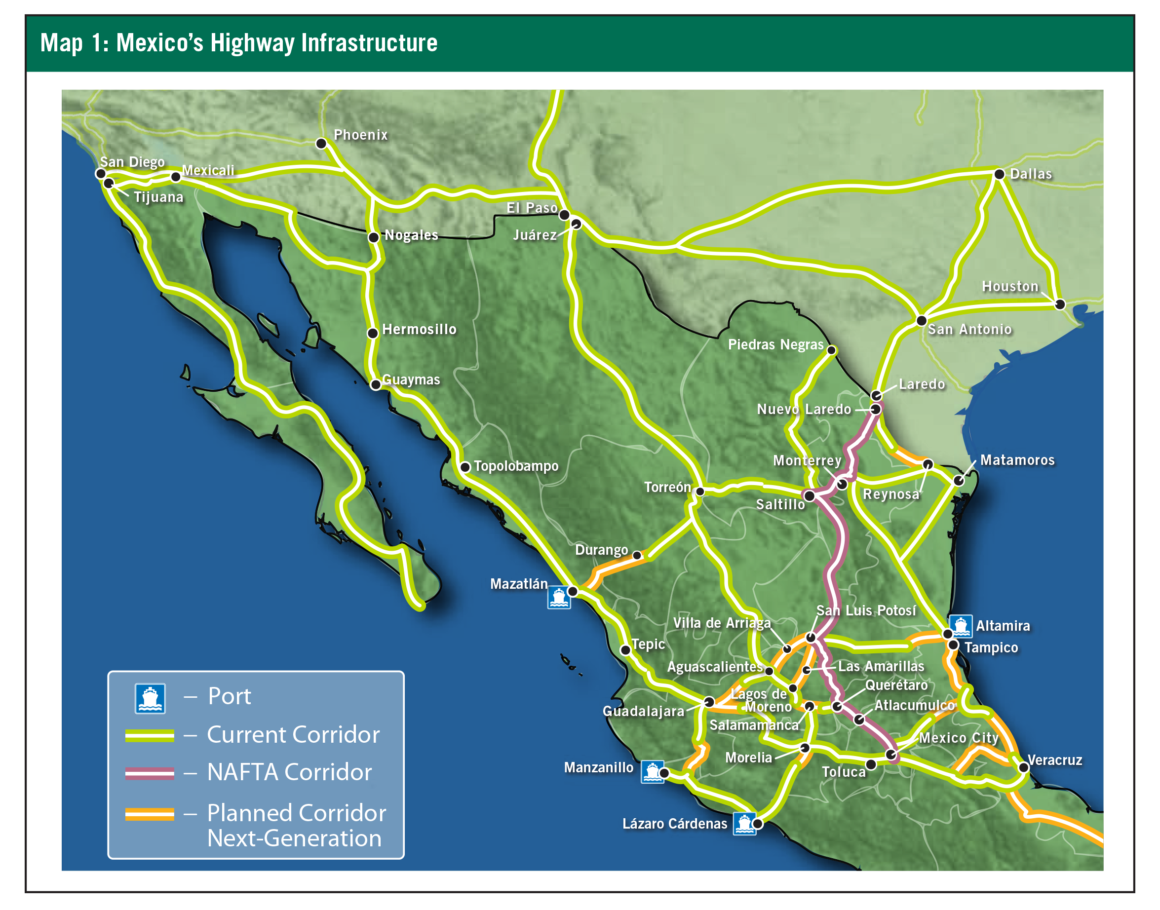
When complete, this 1,242 km Super Highway will serve as the Port of Mazatlán’s gateway to the rest of Mexico, linking it to the Mexican cities of Durango, Torreón, Saltillo, Monterrey, Reynosa, and Matamoros. (See Map 1.) The Port of Mazatlán is very important for Mexico’s agricultural and automotive industries.
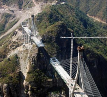
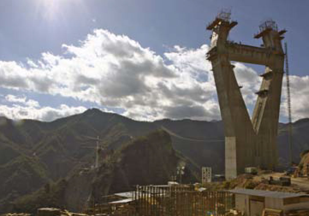
The stretch of highway between Mazatlán and Durango runs 230 km and spans the Western Sierra Madre Mountain range. This challenging terrain has required that a bridge be built — the Baluarte Bridge. It’s an engineering marvel that will be 1.2 km long and 1,280 feet high — making it the longest, highest cable-stayed bridge in all of Latin America. More importantly, it will save travelers roughly 2.5-to-3.5 hours in their commutes between Mazatlán and Durango. The bridge is currently about half complete and is on track to open in 2012.
At a recent press conference, President Calderón announced that the Super Highway will be completed in 2011, before his presidency ends. According to the Transport and Communications Ministry, this east-west corridor is now nearly 70% complete. It has turned out to be one of the NIP’s costliest projects (with a total projected cost of US$1.5 billion), because of the challenging terrain and multiple tunnel and bridge requirements. But when this corridor is done, it will also stand out as one of the NIP’s premier accomplishments.
The Manzanillo-Tampico Corridor
This east-west corridor will run 985 km from Port Manzanillo on the Pacific Coast to Tampico on the Gulf Coast, weaving through the cities of Guadalajara, Aguascalientes, and San Luis Potosí. The project also includes modernizing the short roadway along the Pacific Coast, which connects Manzanillo to Lázaro Cárdenas. To date, however, fewer than 50 km of roadway have been upgraded and modernized along this 985 km corridor.
As it stretches across Central Mexico, this east-west corridor will intersect Mexico’s four major north-south corridors and thus provide ready access to the northern border cities such as Nuevo Laredo, Reynosa, and Juárez. This corridor requires construction on five sections, a total of 448 km. It is estimated that the improved roadway will shorten the driving time coast-to-coast from 18.4 to 14.9 hours and will also serve as a key continental highway for moving goods to and from the northern border cities.
Construction plans for this corridor include several external loops or bypasses designed to enable cross-country traffic to avoid congested city centers. One such project is a 112 km loop around Guadalajara.
Work is currently under way on modernizing and upgrading the roadway connecting Lagos de Moreno and San Luis Potosí. The following segments of this roadway will be widened to four lanes: 34.5 km from Lagos de Moreno to Las Amarillas, 50 km from Las Amarillas to Villa de Arriaga, and 47.6 km from Villa de Arriaga to San Luis Potosí. This particular project is budgeted at US$210 million and is under construction currently with 5.5 km completed so far.
Another external loop or bypass will be built around San Luis Potosí. It will be a 4-lane highway with connecting roads to the cities of Aguascalientes, Nuevo Laredo, and Altamira. Regionally, San Luis Potosí serves as a key transportation hub — equally distant from Mexico City, Guadalajara, and Monterrey. San Luis Potosí is already a rapidly growing manufacturing center, and many multinational companies have located there, including Nestle, Goodyear, Penske, and DHL. However, despite its strategic location, San Luis Potosi still lacks depth as a manufacturing hub.
North-South Projects
The Pacific Coastline Corridor
Now nearly complete, this major north-south corridor extends about 3,075 km and, in time, should integrate Mexico’s northwest and western cities and regions into the fabric of the national economy. Going from north to south, it runs from Nogales in northwest Mexico to Hermosillo; hugs the Pacific coastline as it passes through Guayamas, Topolobampo, and Mazatlán; and then cuts inland and passes through Tepic, Guadalajara, Morelia, and Mexico City.
This project also includes the construction of an extension highway that now connects the cities of Tijuana and Mexicali in the far northwest corner of Mexico to the existing highway that links the cities of Nogales and Hermosillo. Previously, the cities of Tijuana and Mexicali along with the entire peninsula of Baja California were largely detached from the interstate fabric of the Mexican economy. Now that this highway extension is complete, car and truck traffic is able to travel easily, safely, and quickly between Tijuana and Mexico City, as well as to all the other key cities.
This key north-south corridor from Nogales to Mexico City is now largely complete, with various sections having been completed during the past few years. All that’s left to build are three external loops or bypasses so that cross-country traffic can avoid congested city centers. One is a 37 km bypass around Mazatlán connecting the Mazatlán-Culiacán Toll Highway to the north (inaugurated in 1994) and the 152 km Tepic-Villa Unión Highway to the south (inaugurated in 2008). The second is a 25 km bypass around Tepic, which lies along the Tepic-Villa Unión Highway. The third is a 22 km bypass around Culiacán. The tender for these three projects was offered in October of 2009, and the bypasses (all currently under construction) should be complete by 2011.
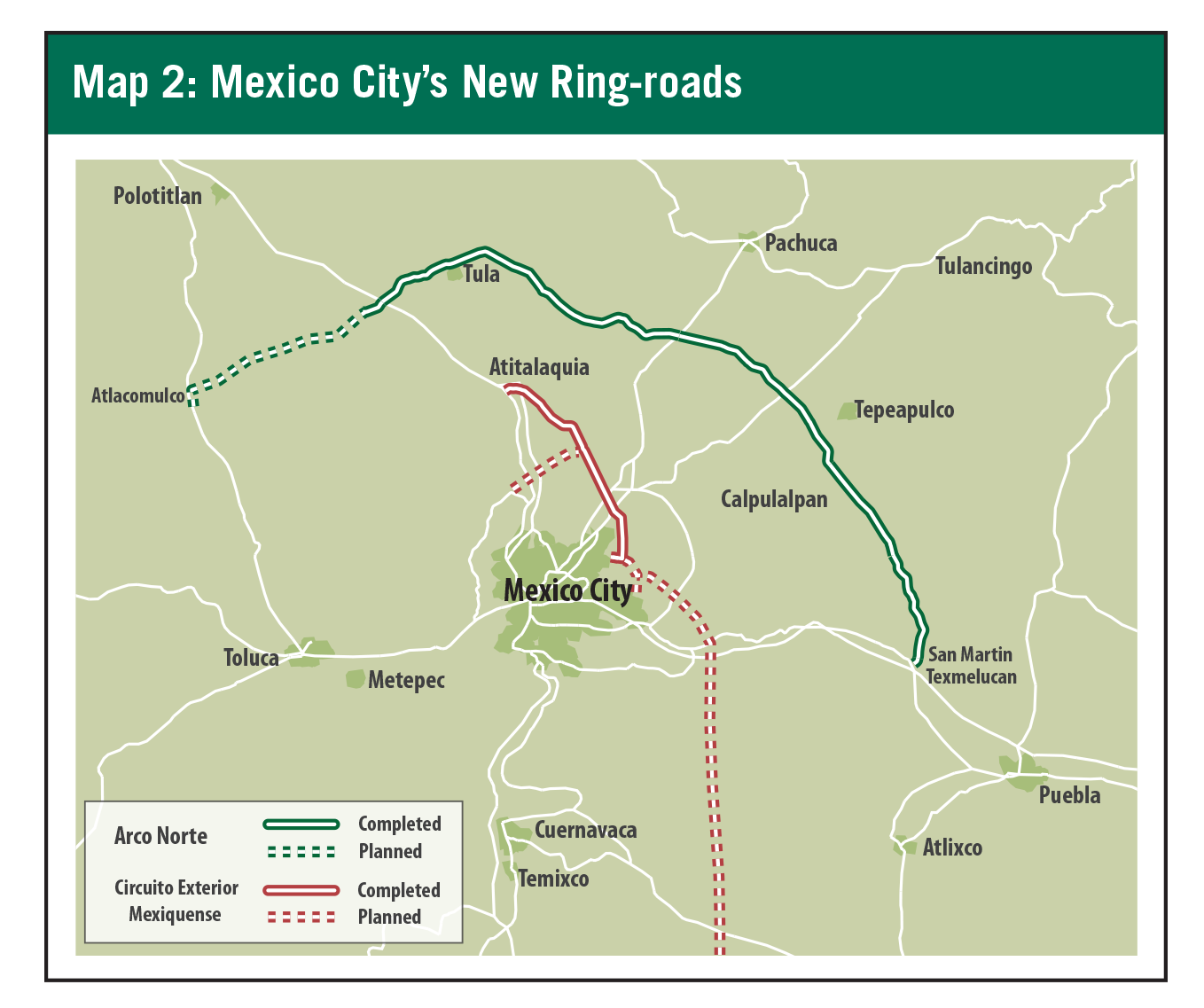
In February 2006, well before the NIP was launched, work had begun on another highly anticipated roadway, the Valle de México Northern Bypass or more commonly known as the Arco Norte. It will span across four states and provide a route from Atlacomulco to Puebla, southeast of Mexico City. (See Map 2.) This 223 km roadway is a part of the Altiplano Corridor and creates an important bypass around Mexico City to improve transportation and reduce congestion around this major logistic corridor.
The last leg of the Pacific Coastline Corridor is the 532 km, 4-lane stretch that connects Guadalajara and Mexico City and passes through Toluca along the way. This highway is called the Atlacomulco-Venta de Bravo Highway and was completed in 2007.
The Gulf Coastline Corridor
This north-south corridor will extend 246 km and connect the cities of Veracruz, Tampico, Monterrey, with a branch road to Matamoros. It consists of a two-lane interstate roadway from Tuxpan up through Altamira, providing an alternate route to northern Mexico without having to travel through the crowded city of Tampico. The tender for this project was proffered toward year-end 2010.
This corridor will facilitate tourist, industrial, and commercial activities along the Gulf Coast. It will also promote greater connectivity to the oil and gas industries and channel their resources to the rest of the country. It will reduce transport costs and time, making travel on this highway much more efficient. It will expedite freight transport from the south-east up to, and beyond, the northern border of Mexico.
The NAFTA or Pan-American Highway
The north-south corridor that extends 1,734 km from Nuevo Laredo along the U.S.-Mexico border to Mexico City is better known as the NAFTA or Pan-American Highway. The NAFTA highway is composed of several smaller highways and has been used as Mexico’s primary north-south freight lane to the U.S. for the past 20 years. It is in effect an extension of U.S. I-35 south into Mexico and remains the most heavily traveled trans-border corridor connecting Mexico and the U.S.
Heading south from the U.S.-Mexico border, the NAFTA Highway starts in Nuevo Laredo, passes through Monterrey, Saltillo, San Luis Potosí, Querétaro, and Mexico City. This highway also has a branch that extends to Piedras Negras which begins in Saltillo and another branch extending to Lázaro Cárdenas through the Salamanca-Morelia highway (inaugurated in 2008.)
Construction is under way on an extension of the NAFTA Highway from Querétaro to Atlacomulco, at the point where the Northern Arc will intersect the Atlacomulco-Venta de Bravo Highway. At present, any freight traffic moving along the NAFTA Highway must travel through Mexico City on its way to or from the Port of Lázaro Cárdenas. When completed, this new extension of the NAFTA Highway (known as the Atlacomulco-Piedras Negras) will permit freight traffic to be routed to or from the port without having to go through Mexico City. In particular, the up-and-coming cities of Querétaro, San Luis Potosí, and Aguascalientes will then have direct access to the Port of Lázaro Cárdenas as well as the Port of Manzanillo.
Mexico City’s Circuito Exterior Mexiquense
Mexico’s transportation planners are working diligently to provide alternate traffic routes to maneuver around Mexico City, the world’s second largest city. One such roadway is the Circuito Exterior Mexiquense, a 445 km long loop surrounding the City that is in stage two of construction. (See Map 2.) Stage one of the project was completed in 2008, a 52.7 km road that connects the México-Querétaro and México-Pachuca highways to the state of Mexico. Stage two will integrate the highways mentioned above to the México-Puebla highway through the development of a road, 38.3 km long, along the eastern part of the city. There are four sections in total being constructed to provide more efficient routes from Mexico City to Toluca and Querétaro.
Buildable land is extremely scarce in Mexico City, and many companies are looking for alternative locations to situate their facilities. Once the planned next-generation corridors are complete, Querétaro will likely be a place of possible expansion. Many aerospace industries have taken interest in Querétaro and with a more integrated interstate network Querétaro will continue to grow into a manufacturing hub.
Conclusion
Few observers today realize how much progress Mexico has made in upgrading and modernizing its network of interstate highways since the NIP was launched in 2007. When complete, its modernized federal highway network will provide greater security and mobility to the population and also facilitate the economic integration of different geographic sectors of the country. With continued public-private collaboration, Mexico can leverage investments to complete the pending road-building projects within the NIP, and they will. Increasing the quality and efficiency of Mexico’s roads will directly impact Mexico’s economic development and continued prosperity.
Author
Brittany Whitfield, Research Analyst based in the Denver office
Leslie Hulse, Vice President and Market Officer for Prologis
About ProLogis
ProLogis is a leading global provider of distribution facilities, with more than 475 million square feet of industrial space (44 million square meters) in markets across North America, Europe, and Asia. The company leases its industrial facilities to more than 4,400 customers, including manufacturers, retailers, transportation companies, third-party logistics providers and other enterprises with large-scale distribution needs.
© Copyright 2011 ProLogis. All rights reserved.
This information should not be construed as an offer to sell or the solicitation of an offer to buy any security of ProLogis. We are not soliciting any action based on this material. It is for the general information of ProLogis’ customers and investors.
This report is based, in part, on public information that we consider reliable, but we do not represent that it is accurate or complete, and it should not be relied on as such. No representation is given with respect to the accuracy or completeness of the information herein. Opinions expressed are our current opinions as of the date appearing on this report only. ProLogis disclaims any and all liability relating to this report, including, without limitation, any express or implied representations or warranties for statements or errors contained in, or omissions from, this report.
Any estimates, projections or predictions given in this report are intended to be forward-looking statements. Although we believe that the expectations in such forward-looking statements are reasonable, we can give no assurance that any forward-looking statements will prove to be correct. Such estimates are subject to actual known and unknown risks, uncertainties, and other factors that could cause actual results to differ materially from those projected. These forward-looking statements speak only as of the date of this report. We expressly disclaim any obligation or undertaking to update or revise any forward-looking statement contained herein to reflect any change in our expectations or any change in circumstances upon which such statement is based.
No part of this material may be (i) copied, photocopied, or duplicated in any form by any means or (ii) redistributed without the prior written consent of ProLogis.
